The Buncombe County GIS web site was primarily
developed to help members of the public answer questions about the geographic
features in Buncombe County. It is designed for the user to be able to use a map
of the county to zoom into an area of interest, and to search for
property information.
This application provides residents and visitors an easy way to find property information in Buncombe County.
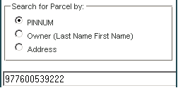
The Search For Parcel Panel searchs and selects parcels by the
either the parcel's PIN, Owner Name, or Address
1. Use the radio dial to select the search method you'd like to use
2. Enter the search criteria, and then hit Enter
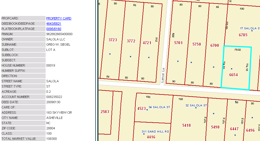
You can also select a parcel manually by clicking on the Select Toool and then clicking inside the parcel on the map.
The results table will list all the information about the selected parcel. From the results table you can view the property card , deed and plat for the parcel.
There are several ways to interact with the map:
1. Use the Basemap Switcher to select the basemap you'd like to interact with
2. Hold down the shift key and drag a box on the map to ZOOM IN
3. Hold Down Ctrl+Shift to ZOOM OUT
4. Roll your mouse roller to zoom in/out
5. Drag the zoom slider to zoom in/out
6. Click on the map and move the mouse to PAN
You can use the measure tools to measure a line, area or to get the location of a point.
1. Open the measure toolbox by clicking on the Measure Tool button
2. Select either the area, distance or location tool depending on what you would
like to measure and then move your mouse over the desired area on the map to
measure.
The results will apear in Measure dialog.
a)
To measue a line move the cursor to the first point of the line you want to measure, and click the left mouse button.
Keep moving the cursor and adding points by
clicking the left mouse button. To end the line double click at the end point.
b) To measure a polygon click the left mouse button at the first point in the polygon. As you move the mouse from this location, you will see the line stretching to the
current position.
Click the second point of the polygon. The first segment draws, and the polygon now stretches to the current position from the last point as well as
to the initial point. To
end the polygon double click at the end point.
c) To get the location of a point, click on the map. The coordinates at the location you clicked will be displayed in the Measure dialog.
3. After drawing the area on the map and getting the results, to clear the map and
close the measure tool ,click on the tool again .
You can click on the Export Map to PDF button to print or save your map.
In the print dialog you can enter a title and choose the template size. A new internet window will open, you can either print from there or
save the file as a pdf.
**if pop blockers are turned on, the report page may not display automatically.
The following browsers are supported: Microsoft IE 7/8/9, Mozilla Firefox, Google Chrome and Apple Safari.